
These maps and documents come from the Chelsea history archive that has been on this site since 2013. Each used to sit on its own page with no explanation. Here they are together, roughly in date order, with a note on what each one shows. Some are reproductions drawn long after the date in their title; where a map shows something that came later, we say so. Click any image to see it full size.
Where Chelsea is
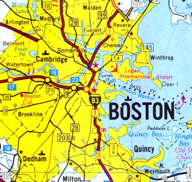
For orientation: Chelsea sits just north of Boston across the Mystic River and Chelsea Creek, between Everett, Revere and East Boston, with Winthrop and Logan Airport to the east. Every map below covers some part of this ground.
The peninsula in 1624
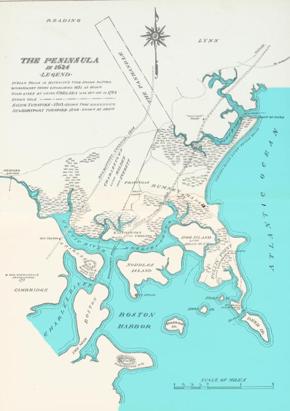
Titled “The Peninsula in 1624,” this is a later reconstruction, not a map made in 1624. Its legend shows Indian trails “in Maverick’s time” as dotted lines, the Winnisimmet Ferry established in 1631, the town lines by which Chelsea was set off in 1739, and the Salem Turnpike of 1803 and Newburyport Turnpike of 1804. Winnisimmet, later Chelsea, sits on the Mystic River across from Charlestown, with Rumney Marsh to the north, Hog Island (later Belle Isle) and Pullin Point (Winthrop) to the east, and Noddles Island (East Boston) to the south.
Indian trails, 1630
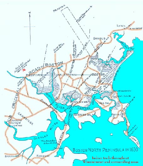
“Boston North Peninsula in 1630” traces, in orange, the Indian trails that crossed Winnisimmet and the surrounding area, from Medford and Cambridge out to Saugus, Lynn and Pullin Point. The trail marked “Our original road to Boston” runs through Medford and Charlestown.
The Bill Farm, 1690
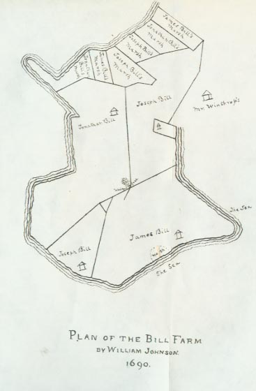
“Plan of the Bill Farm by William Johnson, 1690,” at Pullin Point, now Winthrop, which was part of Chelsea until 1846. It divides the land among members of the Bill family, with parcels marked for James, Joseph and Jonathan Bill, and shows “Mr. Winthrop’s” land next door and the sea on two sides.
Winnisimmet Village
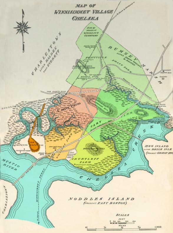
Winnisimmet Village, which the archive dated to the early 1700s, colored by farm: the Carter Farm, the Williams Farm, the Cary land, the Shurtleff Farm and the Pratt Farm toward Rumney Marsh. It also marks Powder Horn Hill, Bellingham Hill, the Winnisimmet Ferry to Boston, the Mystic River toll bridge, and the site of the present Woodlawn Cemetery. Like the 1624 map, it was drawn later; it notes the U.S. Naval Hospital and the Marine Hospital, both 19th-century.
Boston Harbor, 1711
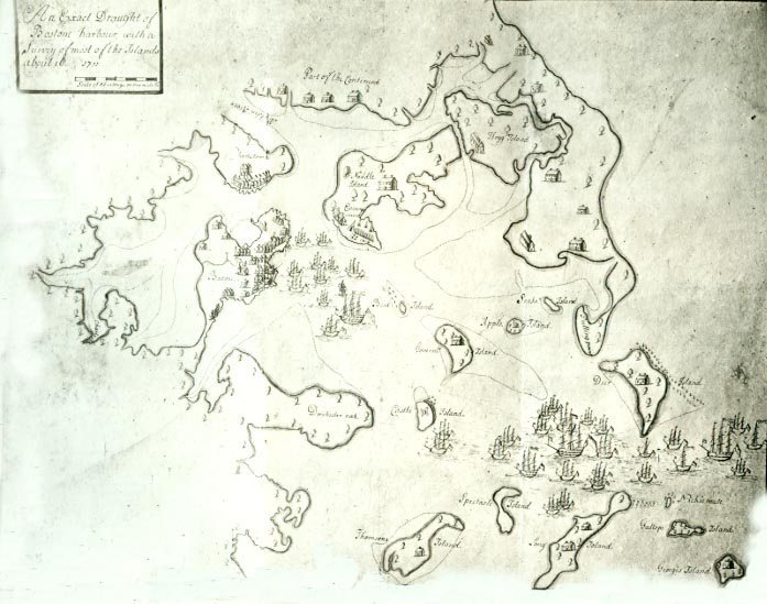
“An Exact Draught of Boston Harbour with a Survey of most of the Islands about it,” which the archive dated to 1711. Houses are drawn on Noddles Island and Hog Island, and a fleet of ships rides at anchor between Deer Island and the outer islands.
Chelsea in 1739
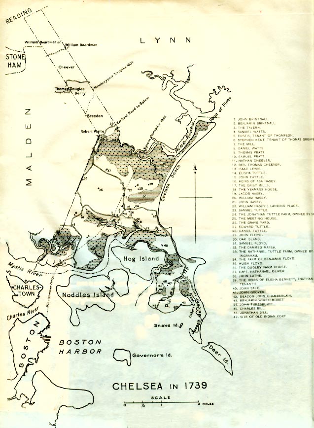
Chelsea in 1739, the year it was set off from Boston as its own town. Forty-seven numbered sites are keyed in the margin: the farms and houses of the Brintnall, Watts, Pratt, Cheever, Tuttle, Hasey, Floyd and Bill families, among others, plus the tavern, the grist mills, the meeting house, the grave yard, the dammed marsh and the site of an old Indian fort. The Salem and Newburyport turnpikes, built decades later, are drawn in for reference.
The Bellingham farms
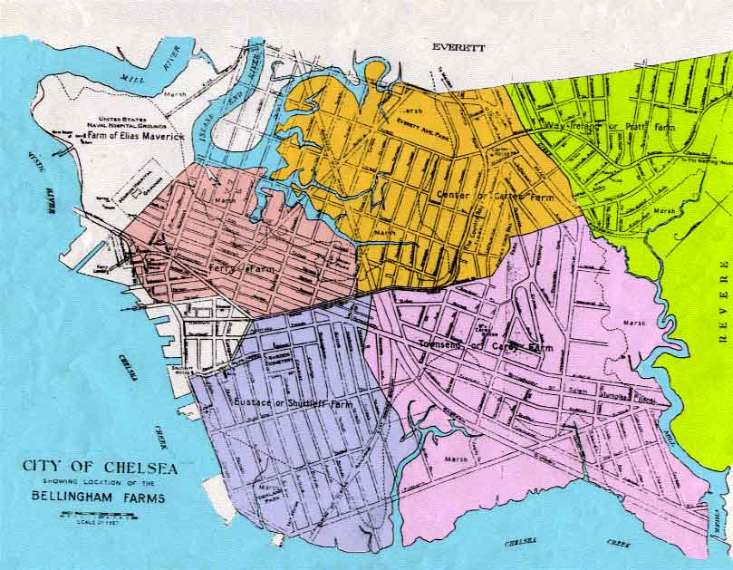
“City of Chelsea, showing location of the Bellingham Farms.” The colonial farms are laid over the later street grid: the Ferry Farm, the Center or Carter Farm, the Way, Ireton or Pratt Farm, the Townsend or Carey Farm, the Eustace or Shurtleff Farm, and the farm of Elias Maverick, later the U.S. Naval Hospital grounds. It is a quick way to see which farm your street was carved out of.
Winthrop, 1903
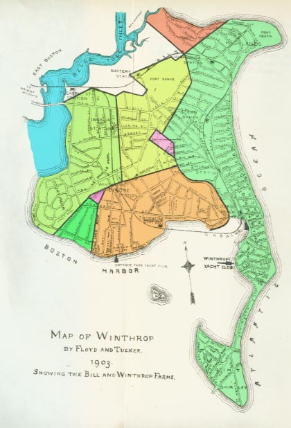
“Map of Winthrop by Floyd and Tucker, 1903, showing the Bill and Winthrop Farms.” The streets of Winthrop in 1903, colored to show the old farm boundaries from the Bill Farm plan above.
The 1973 fire
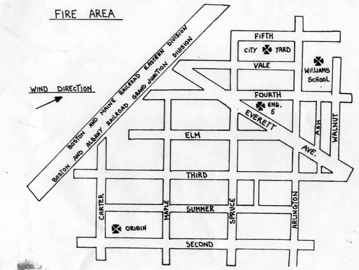
A hand-drawn map of the fire area on October 14, 1973. It marks the origin near Carter and Second streets, the wind direction, and the railroad lines along the western edge, and shows Engine 5 on Everett Avenue, the City Yard on Fifth Street and the Williams School on Walnut Street.
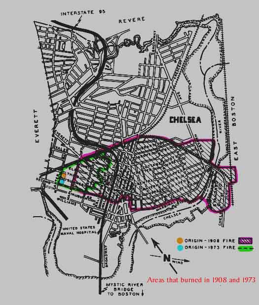
The areas that burned in 1908 and in 1973. The 1908 fire, outlined in purple, swept east across the city to Chelsea Creek. The 1973 fire, outlined in green, was smaller and further west. The two started close to each other. Our full account of the 1973 fire is The Great Chelsea Fire of 1973.
A modern street map
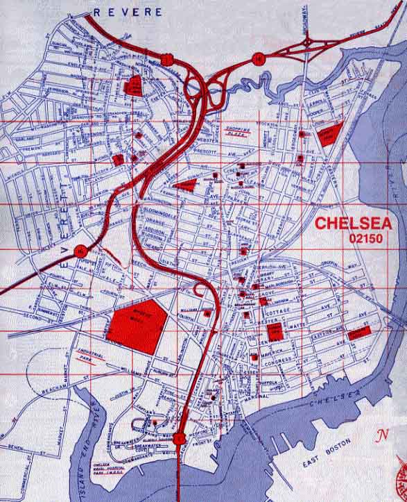
A gridded street map of Chelsea, 02150, from a later 20th-century street guide, with Route 1 running north to Revere and Route 16 crossing from Everett. Compare it with the farm maps above.
Also from the archive
A toll receipt from the Chelsea Bridge, 1804
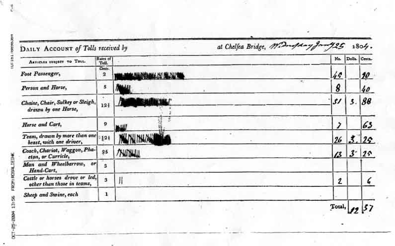
The “Daily Account of Tolls received at Chelsea Bridge” for Wednesday, January 25, 1804. A walker paid 2 cents, a person on horseback 5, a one-horse chaise or sleigh 12½, and a coach or wagon 25. That day the keeper counted 45 people on foot, 8 on horseback, 31 chaises and sleighs, 7 horse carts, 26 teams, 13 coaches and wagons and 2 head of cattle, for a total of $12.37.
Looking for a home, 1908
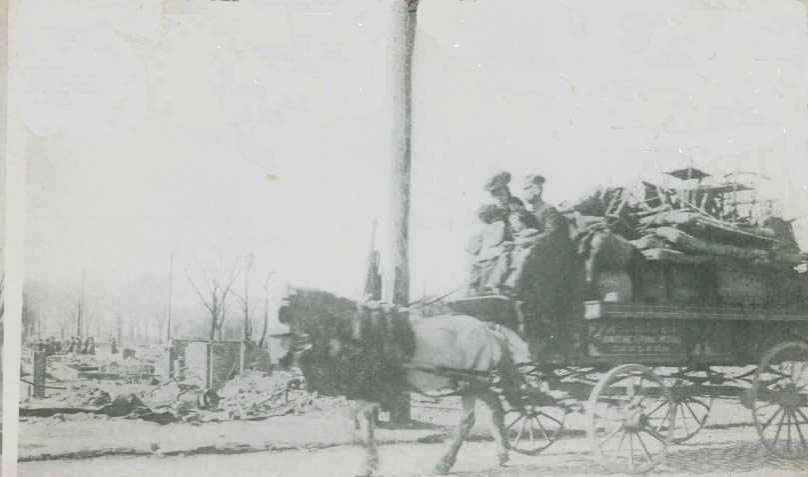
A family rides a horse-drawn wagon piled with furniture past burned-out lots after the Great Chelsea Fire of 1908, which the archive titled “Looking for a Home.” More photographs are on our Chelsea Fire 1908 page.
President Taft in Chelsea, 1912
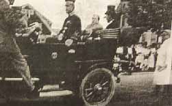
According to the archive, President William Howard Taft visited Chelsea on September 19, 1912, rode through the city by motorcade and gave a speech at the State Armory.
Chelsea and the Tobin Bridge
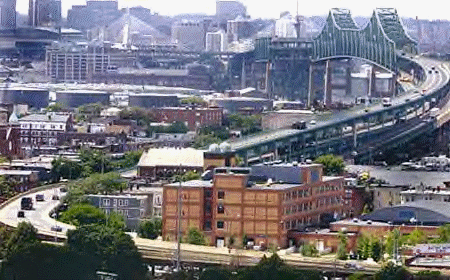
A view across Chelsea’s rooftops to the Tobin Bridge and the Boston skyline beyond. This was the archive’s front-page picture, titled simply “The City of Chelsea.”