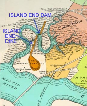
The first marked change in the geography of Chelsea was made in 1789
by the construction of the Island End Dike and Dam. At high tide the
sea would flow in and cover the southwesterly side of the creek and,
what is now Eastern Avenue, on the east. Tide water would come in
from the lower Mystic River to the west up the Island End Creek, and
overflow the marshes to within a few feet of Cary Square, and up to
about a block from City Hall. If Broadway had existed then it would
have been under water between Cary Avenue and Parker Street.
Everything east, where Eastern Avenue, Highland, Park, and part of
Marginal Street are today was under water flowing in from Chelsea
Creek with the high tide.On February 17, 1789, a charter
was granted by the General Court, to Samuel Watts and twelve other
marsh owners, to build a dike. The dike was built, extending from
Jonathan Green’s farm (Admiral’s Hill), across a marsh and Island End
River to high ground near the Everett line. This dike, after a few
years, became useless. When the Winnisimmet Land Company purchased
the Thomas Furber farm, comprising 133 acres of marsh land giving
them a total of 200 acres of the 300 acres of marsh land. They also
secured all rights to the dike. The Land Company revived the charter
of 1789 and in 1845 entered into an agreement with the United States
government to rebuild the dike, each party paying one-half the cost.
The dike was rebuilt in accordance to plans of three of the best
Civil Engineers in the country at a cost of $10,000. This dike was
well built and withstood the wear for sixty-five years. It was said
that in 1869 the dike and deeds were transferred to and accepted by
the City of Chelsea. There was nothing in the city records of that
year to show any such action occurred. The next year, there was an
item in the records of 1870, of the construction of a new tide gate
in the dike at a cost of $8000.00.